Takachiho Chō
Local name: 高千穂町
Located in Nishiusuki-gun, Miyazaki Coordinates: 32°44′49″ N 131°18′52″ E
- Population
- 13,401
- 13.4K
- Elevation
- 549 m
- above sea level
- Local time
- UTC+09:00
- Asia/Tokyo · UTC+09:00
- Airports
- KMJ Kumamoto Airport44 km
- OIT Oita Airport90 km
About Takachiho Chō
Takachiho Chō is a municipality. Location: Nishiusuki-gun, Miyazaki. Population: 13,401. Elevation: 549 m.
Takachiho (高千穂町, Takachiho-chō) is a town in Nishiusuki District, Miyazaki Prefecture, Japan. As of 1 October 2023, the town has an estimated population of 11,065 in 4865 households, and a population density of 47 persons per km2. The total area of the town is 237.54 square kilometres (91.71 sq mi).
Source: Wikipedia · CC BY-SA 4.0
Travel notes for Takachiho Chō
From Wikivoyage
Takachiho (高千穂) is a town in Miyazaki, Kyushu. Both a natural wonder and an important religious site, Takachiho draws over a million Japanese tourists yearly, but few foreigners make it this far.
Understand+
Takachiho Gorge is an impressive ravine with countless waterfalls cascading into it, while nearby Ama-no-Iwato Shrine contains the cave where, according to myth, the sun goddess Amaterasu hid until Ame-no-Uzume lured her out. Another legend suggests that this is where Amaterasu's grandson Ninigi-no-Mikoto descended to earth to establish Japan's imperial family, but that particular claim is contested by Takachiho-no-mine in Kirishima National Park to the south.
1 Takachihocho Kankokyokai Information Centre (高千穂町観光協会 観光案内所), 804 Mitai, ☏ +81 98-272-3031. Daily 08:30-17:00. Visit the office or see the website for general tourist information. (updated Aug 2024)
Get in+
By bus:
Takachiho is deep in the mountains in the northwest of Miyazaki prefecture, and is easier to reach from the neighboring prefectures. When planning a day trip, the fastest public transport route will be a bus from Nobeoka which takes you one and a half hours. On the other hand, the bus from Kumamoto arrives at 12:00 and departs at 16:30, leaving you on a very tight four and a half hour timeframe.
From Miyazaki City, take the JR Nippo Line to Nobeoka (1 hr 15 min, ¥1700 by special express), then connect to the Kumamoto bus (departs 07:30 and 15:30), reaching Takachiho in one hour (¥1740). This is the best solution for a daytrip, leaving Miyazaki at 06:00 allows one to catch the 07:30 bus, and leaving with the 18:29 bus allows 10 hours to visit. This is also the fastest route if coming in from Oita to the north.
From Kumamoto City, the inter-city bus to Nobeoka reaches Takachiho in about 3 hr 10 min (¥2300), passing by Kumamoto Airport (2 hr, ¥2100) along the way. Pay when exiting the bus, or purchase a discounted round-trip double ticket (valid for 10 days) from the vending machine at Kumamoto central bus terminal (¥4000). The bus leaves at 09:11 from JR Kumamoto Station (09:22 from the central bus terminal) and arrives at 12:19 in Takachiho. Westbound buses depart Takachiho at 16:57 and reach Kumamoto central bus terminal at 19:50 (JR Kumamoto station 8 minutes later). The Kyusan express buses from Kumamoto and the Miyako express buses from Nobeoka are operated by two different companies that do not accept each other's prepaid tickets, but the local buses will accept the tickets of either express bus company.
From Fukuoka, direct buses from the Nishitetsu Tenjin Bus Terminal connect to Takachiho in 3 hr 15 min (¥4020, Sep 2018).
By car:
Source: Wikivoyage · CC BY-SA 4.0 · abridged
Places bordering Takachiho Chō
- Hinokage
- Gokase Chō
- Morotsuka Son
- Takamori Machi
- Yamato Chō
- Takedamachi
- Bungo-ōno Shi
Population of Takachiho Chō over time
| 2010 | 13,723 | |
|---|---|---|
| 2014 | 12,861 | |
| 2015 | 12,755 | |
| 2021 | 11,642 |
Censuses and official estimates; source: Wikidata.
Climate of Takachiho Chō
Best months for sightseeingBest months for sightseeing: May–July, September–October.
This month · November
Outside the best season
Day 14° · Night 6° · Rain 87 mm
Better nearby cities in November
- Nobeoka · 38 km southeast18°
- Ōita · 60 km northeast18°
- Beppu · 62 km north17°
- Hottest month
- August (day 27°)
- Coldest month
- January (night -2°)
- Wettest month
- July (462 mm)
- Driest month
- December (63 mm)
Bars: average monthly low and high temperature. Below: precipitation. Monthly averages for 1970–2000 at about 18 km resolution, adjusted for elevation. Highlighted months are mild and relatively dry. Source: WorldClim 2.1 (CC BY 4.0).
Show values as a table
| Month | Jan | Feb | Mar | Apr | May | Jun | Jul | Aug | Sep | Oct | Nov | Dec |
|---|---|---|---|---|---|---|---|---|---|---|---|---|
| Average high (°C) | 6° | 7° | 10° | 16° | 20° | 23° | 26° | 27° | 24° | 19° | 14° | 9° |
| Average low (°C) | -2° | -1° | 2° | 7° | 12° | 16° | 20° | 21° | 17° | 11° | 6° | 0° |
| Precipitation (mm) | 72 | 105 | 156 | 211 | 251 | 440 | 462 | 307 | 249 | 139 | 87 | 63 |
Other places to visit in this season: May June July September October
How to get to Takachiho Chō
The nearest airport is Kumamoto Airport (KMJ), 44 km to the west as the crow flies. The nearest large city is Nobeoka, 38 km to the southeast.
Airports
- Kumamoto Airport (KMJ) Kumamoto 44 kmwest
- Oita Airport (OIT) Oita 90 kmnortheast
- Miyazaki Airport (KMI) Miyazaki 97 kmsouth
Nearby large cities
- Nobeoka Population: 119.5K 38 kmsoutheast
- Ōita Population: 477.7K 60 kmnortheast
- Beppu Population: 122.6K 61 kmnorth
- Honmachi Population: 123.1K 72 kmwest
- Omuta Population: 132K 87 kmwest
Straight-line distances; road distances are longer. Airport data: OurAirports.
Day trips from Takachiho Chō
Within 100 km: 5 historic and cultural sites, 15 natural sites, 10 lakes, rivers and coasts.
0–25 km2 places
- Mount Ōkueyama Mountain 19 kmE
- Mount Sobo Mountain 10 kmN
25–60 km9 places
- Kyūshū Island 46 kmSW
- Mimigawa River River 54 kmSE
- Mount Osuzu Mountain 51 kmS
- Kumamoto castle Historic site 57 kmW
60–100 km19 places
- Ooyodo River River 96 kmS
- Chikugo River River 100 kmNW
- Mount Unzen Mountain 97 kmW
- Hi Kawa River 66 kmW
Straight-line distances.
Nearby attractions & nature
Everything nearby-
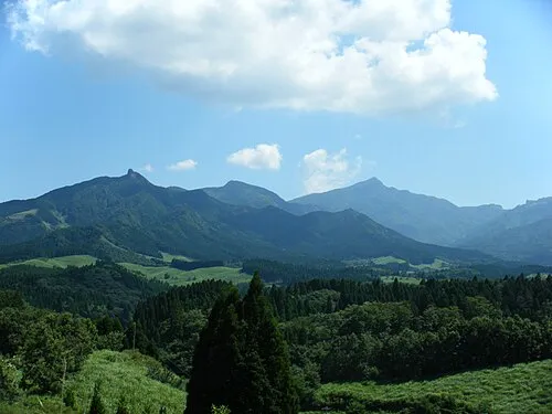 Mount Sobo Mountain, Bungo-ōno Shi9.5 km N
-
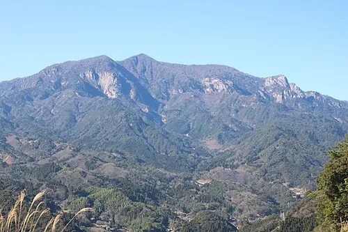 Mount Ōkueyama Mountain, Nobeoka Shi19 km E
Sources & licences
Data last updated: · 2 independent sources