Karuizawa Machi
Local name: 軽井沢町
Located in Kitasaku-gun, Nagano Coordinates: 36°21′25″ N 138°35′22″ E

- Population
- 19,965
- 20K
- Elevation
- 973 m
- above sea level
- Local time
- UTC+09:00
- Asia/Tokyo · UTC+09:00
- Places inside
- 2
- listed under Karuizawa Machi
- Airports
- MMJ Shinshu-Matsumoto Airport63 km
- TOY Toyama Kitokito Airport130 km
About Karuizawa Machi
Karuizawa Machi is a municipality. Location: Kitasaku-gun, Nagano. Population: 19,965. Elevation: 973 m.
Karuizawa (軽井沢町, Karuizawa-machi) is a resort town in Nagano Prefecture, Japan. As of 1 October 2025, it had an estimated population of 21,834 in 11,285 households, and a population density of 139 persons per km2. The total area of the town is 156.03 km2 (60.24 sq mi). Originally, there was a stage station (shukuba) called Karuisawa-shuku on the Nakasendō. The Shin'etsu Line opened in 1888 and the town became popular as a Western-style hill station around that time.
Source: Wikipedia · CC BY-SA 4.0
Photos of Karuizawa Machi
-
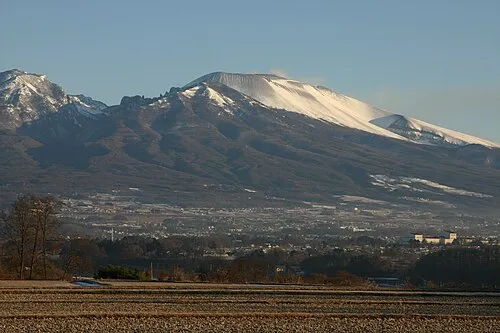
Mount Asama Yu.nakai · CC BY-SA 3.0

Travel notes for Karuizawa Machi
From Wikivoyage
Karuizawa (軽井沢) is a town in Nagano prefecture, famous as an upscale summer resort.
Understand+
Karuizawa, at about 1000m above sea-level, is a famous mountain resort in eastern Nagano Prefecture. Elegant summer houses are scattered through the nearby forests, while the central part of the town is elegantly laid out with restaurants, cafes and boutiques.
History:
In the late 1800s, Canadian missionary Alexander Croft Shaw said that Karuizawa was a wonderful summer resort. Since then, foreigners have been flocking to Karuizawa. It was remarkable for its unspoilt nature, and climate that was several degrees cooler than Tokyo in the summer (and still is!). As such, there are a number of Christian churches, which is very unusual for a small Japanese town. You can also see a variety of western-style buildings dotted around.
Climate:
The climate in Karuizawa is known for being remarkably cool, and generally is about 5°C cooler than Tokyo in the summer. It also often gets quite misty.
Tourist information:
The local tourist association has two official multilingual guide sites, one here, and one here. It's unclear why there are two of them. The more, the merrier? There's also an official pamphlet.
Dog tourism: Amusingly, Karuizawa promotes itself as a "dog tourism" location and has an official website full of dog-friendly locations and activities. The website is only in Japanese, but if you're passionate enough about spending time with your dog, surely you can figure it out (alternatively, you can just look at the gallery of cute dog pictures).
1 Karuizawa Tourism Hall (軽井沢観光会館 Karuizawa Kanko Kaikan), ☏ +81 267-42-5538. 9:00–17:00 (18:00 in the summer). Large wooden tourism information building. There are also locations in Naka-karuizawa Station and Karuizawa Station. Free. (updated Dec 2025)
Get in+
1 Naka-Karuizawa Station (中軽井沢駅 Central Karuizawa Station). JR East Shinano Line (しなの鉄道線). (updated Dec 2025)
2 Karuizawa Station (軽井沢駅). JR East Shinano Line (しなの鉄道線). (updated Dec 2025)
Shinkansen (bullet train) from Tokyo (70 minutes, ¥5250); Nagano (30 min, ¥3070)
Shinano railway from Nagano (90 minutes, ¥1590); Togura Station (in Chikuma; 70 min, ¥1170)
Bus from Tokyo's Ikebukuro Station (2-3 hours, ¥2500).
Source: Wikivoyage · CC BY-SA 4.0 · abridged
Places bordering Karuizawa Machi
- Saku
- Miyota-machi
- Takasaki
- Annaka
- Naganohara Machi
- Tsumagoi Mura
Population of Karuizawa Machi over time
| 2010 | 19,018 | |
|---|---|---|
| 2015 | 18,994 | |
| 2021 | 19,648 |
Censuses and official estimates; source: Wikidata.
Climate of Karuizawa Machi
Best months for sightseeingBest months for sightseeing: May–September.
This month · November
A cold month
Day 12° · Night 1° · Rain 65 mm
Better nearby cities in November
- Kofu · 77 km south17°
- Isehara · 125 km southeast18°
- Fujinomiya · 127 km south18°
- Hottest month
- August (day 27°)
- Coldest month
- January (night -7°)
- Wettest month
- September (212 mm)
- Driest month
- December (34 mm)
Bars: average monthly low and high temperature. Below: precipitation. Monthly averages for 1970–2000 at about 18 km resolution, adjusted for elevation. Highlighted months are mild and relatively dry. Source: WorldClim 2.1 (CC BY 4.0).
Show values as a table
| Month | Jan | Feb | Mar | Apr | May | Jun | Jul | Aug | Sep | Oct | Nov | Dec |
|---|---|---|---|---|---|---|---|---|---|---|---|---|
| Average high (°C) | 3° | 3° | 7° | 14° | 19° | 22° | 26° | 27° | 22° | 17° | 12° | 6° |
| Average low (°C) | -7° | -6° | -4° | 2° | 7° | 12° | 17° | 18° | 14° | 7° | 1° | -4° |
| Precipitation (mm) | 41 | 54 | 75 | 103 | 124 | 201 | 206 | 208 | 212 | 126 | 65 | 34 |
Other places to visit in this season: May June July August September
How to get to Karuizawa Machi
The nearest airport is Shinshu-Matsumoto Airport (MMJ), 63 km to the west as the crow flies. For international flights: Tokyo Haneda International Airport (HND) (140 km). The nearest large city is Ueda, 28 km to the west.
Airports
- Shinshu-Matsumoto Airport (MMJ) Matsumoto 63 kmwest
- Toyama Kitokito Airport (TOY) Toyama 130 kmwest
- Tokyo Haneda International Airport (HND) Tokyo 140 kmsoutheast
Nearby large cities
- Ueda Population: 157.5K 28 kmwest
- Takasaki Population: 373K 38 kmeast
- Maebashi Population: 332.1K 45 kmeast
- Nagano Population: 372.8K 49 kmnorthwest
- Isesaki Population: 211.8K 55 kmeast
Straight-line distances; road distances are longer. Airport data: OurAirports.
Day trips from Karuizawa Machi
Within 100 km: 4 historic and cultural sites, 66 natural sites, 19 lakes, rivers and coasts.
0–25 km2 places
- Mount Asama Mountain 8 kmNW
- Mount Myōgi Mountain 16 kmSE
25–60 km26 places
- Mount Kamuriki Mountain 45 kmW
- Lake Haruna Lake 28 kmNE
- Naeba-san Mountain 55 kmN
- Mount Akagi Mountain 57 kmE
60–100 km61 places
- Honshu Island 66 kmSW
- Lake Shoji Lake 96 kmS
- Mount Senjō Mountain 80 kmSW
- Mount Nokogiri Mountain 73 kmSW
Straight-line distances.
Places in Karuizawa Machi
2 placesKaruizawa
Population: 20K
-
Sources & licences
Data last updated: · 2 independent sources