Nozawa-onsen Mura
Located in Shimotakai-gun, Nagano Coordinates: 36°55′53″ N 138°28′01″ E

- Population
- 3,842
- 3.8K
- Elevation
- 946 m
- above sea level
- Local time
- UTC+09:00
- Asia/Tokyo · UTC+09:00
- Airports
- MMJ Shinshu-Matsumoto Airport98 km
- TOY Toyama Kitokito Airport118 km
About Nozawa-onsen Mura
Nozawa-onsen Mura is a municipality. Location: Shimotakai-gun, Nagano. Population: 3,842. Elevation: 946 m.
Nozawaonsen (野沢温泉村, Nozawaonsen-mura) is a village located in Nagano Prefecture, Japan. As of 1 April 2019, the village had an estimated population of 3,653 in 1,395 households and a population density of 63 persons per km². The total area of the village is 57.96 square kilometres (22.38 sq mi).
Source: Wikipedia · CC BY-SA 4.0
Photos of Nozawa-onsen Mura
-

ninpuukamui · CC BY-SA 3.0 -

Fin 22 · CC BY-SA 4.0 -

Zacharymccune · CC BY-SA 4.0 -

Qurren · CC BY-SA 4.0 -

Qurren · CC BY-SA 4.0


Travel notes for Nozawa-onsen Mura
From Wikivoyage
Nozawa Onsen (野沢温泉 Nozawaonsen) is a rural village turned ski resort in Nagano, Japan.
Understand+
It began as a hot spring (onsen) resort, but it's now best known as a major ski destination that is particularly popular among Australian visitors to Japan.
It is home to about 3,000 people (1 March 2021)
Tourist information:
Nozawa Ski (official site)
Get in+
By plane:
There are no major airports near Nozawa. Most visitors fly into Tokyo, or perhaps Nagoya, and continue by train.
By train:
Nozawa is not directly served by trains. The nearest station is Iiyama on the Hokuriku Shinkansen, 1 hr 45 min from Tokyo. From Iiyama, Nozawa Onsen Liner direct express buses connect to Nozawa Onsen in 25 minutes (¥600/300 adult/child, as of Jan 2026).
Source: Wikivoyage · CC BY-SA 4.0 · abridged
Places bordering Nozawa-onsen Mura
- Iiyama
- Kijimadaira Mura
- Sakae Mura
Population of Nozawa-onsen Mura over time
| 2010 | 3,853 | |
|---|---|---|
| 2015 | 3,479 | |
| 2021 | 3,286 |
Censuses and official estimates; source: Wikidata.
Climate of Nozawa-onsen Mura
Best months for sightseeingBest months for sightseeing: May–September.
This month · November
A wet month
Day 9° · Night 0° · Rain 113 mm
Better nearby cities in November
- Kofu · 141 km south17°
- Isehara · 186 km southeast18°
- Fujinomiya · 191 km south18°
- Hottest month
- August (day 26°)
- Coldest month
- January (night -9°)
- Wettest month
- July (186 mm)
- Driest month
- April (93 mm)
Bars: average monthly low and high temperature. Below: precipitation. Monthly averages for 1970–2000 at about 18 km resolution, adjusted for elevation. Highlighted months are mild and relatively dry. Source: WorldClim 2.1 (CC BY 4.0).
Show values as a table
| Month | Jan | Feb | Mar | Apr | May | Jun | Jul | Aug | Sep | Oct | Nov | Dec |
|---|---|---|---|---|---|---|---|---|---|---|---|---|
| Average high (°C) | 0° | 0° | 3° | 12° | 18° | 21° | 24° | 26° | 21° | 15° | 9° | 3° |
| Average low (°C) | -9° | -9° | -6° | 1° | 6° | 12° | 16° | 17° | 13° | 6° | 0° | -5° |
| Precipitation (mm) | 138 | 108 | 97 | 93 | 101 | 156 | 186 | 153 | 184 | 133 | 113 | 126 |
Other places to visit in this season: May June July August September
How to get to Nozawa-onsen Mura
The nearest airport is Shinshu-Matsumoto Airport (MMJ), 98 km to the southwest as the crow flies. The nearest large city is Jōetsu, 32 km to the northwest.
Airports
- Shinshu-Matsumoto Airport (MMJ) Matsumoto 98 kmsouthwest
- Toyama Kitokito Airport (TOY) Toyama 118 kmwest
- Sado Airport (SDS) Sado 125 kmnorth
Nearby large cities
- Jōetsu Population: 189.4K 32 kmnorthwest
- Nagano Population: 372.8K 40 kmsouthwest
- Ueda Population: 157.5K 61 kmsouth
- Nagaoka Population: 266.9K 67 kmnortheast
- Maebashi Population: 332.1K 81 kmsoutheast
Straight-line distances; road distances are longer. Airport data: OurAirports.
Day trips from Nozawa-onsen Mura
Within 100 km: 2 historic and cultural sites, 42 natural sites, 11 lakes, rivers and coasts.
0–25 km2 places
- Lake Nojiri Lake 25 kmSW
- Naeba-san Mountain 22 kmSE
25–60 km16 places
- Tanigawa Dake Mountain 43 kmE
- Mount Myōkō Mountain 32 kmW
- Mount Kurohime Mountain 32 kmSW
- Uono River River 51 kmNE
60–100 km37 places
- Umeda Ko Lake 98 kmSE
- Mount Shibutsu Mountain 63 kmE
- Mount Aizu-Komagatake Mountain 80 kmE
- Mount Myōgi Mountain 76 kmS
Straight-line distances.
Nearby attractions & nature
Everything nearby-
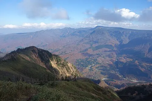 Naeba-san Mountain, Yuzawa Machi22 km SE
-
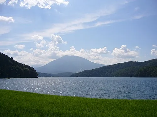 Lake Nojiri Lake, Nagano25 km SW
Sources & licences
Data last updated: · 2 independent sources