- Population
- 29,123
- 29.1K
- Elevation
- 162 m
- above sea level
- Local time
- UTC+09:00
- Asia/Tokyo · UTC+09:00
- Airports
- KIJ Niigata Airport101 km
- SDS Sado Airport118 km
About Muikamachi
Muikamachi is a town. Location: Minamiuonuma, Niigata. Population: 29,123. Elevation: 162 m.
Muikamachi (六日町, Muikamachi) was a town located in Minamiuonuma District, Niigata Prefecture, Japan. As of 2003, the town had an estimated population of 28,687 and a density of 108.75 persons per km2. The total area was 263.79 km2. Muikamachi was a popular destination for skiers. On November 1, 2004, Muikamachi, along with the town of Yamato (also from Minamiuonuma District), was merged to create the city of Minamiuonuma.
Source: Wikipedia · CC BY-SA 4.0
At a glance
- Built
- 1900
Source: Wikidata
Climate of Muikamachi
Best months for sightseeingBest months for sightseeing: May–June, September–October.
This month · November
A wet month
Day 13° · Night 5° · Rain 152 mm
Better nearby cities in November
- Kofu · 158 km south17°
- Isehara · 189 km south18°
- Odawara · 203 km south19°
- Hottest month
- August (day 30°)
- Coldest month
- January (night -5°)
- Wettest month
- January (215 mm)
- Driest month
- May (107 mm)
Bars: average monthly low and high temperature. Below: precipitation. Monthly averages for 1970–2000 at about 18 km resolution, adjusted for elevation. Highlighted months are mild and relatively dry. Source: WorldClim 2.1 (CC BY 4.0).
Show values as a table
| Month | Jan | Feb | Mar | Apr | May | Jun | Jul | Aug | Sep | Oct | Nov | Dec |
|---|---|---|---|---|---|---|---|---|---|---|---|---|
| Average high (°C) | 3° | 4° | 7° | 15° | 21° | 24° | 28° | 30° | 25° | 19° | 13° | 7° |
| Average low (°C) | -5° | -4° | -2° | 5° | 11° | 16° | 20° | 21° | 17° | 11° | 5° | -1° |
| Precipitation (mm) | 215 | 159 | 119 | 109 | 107 | 154 | 195 | 165 | 195 | 158 | 152 | 209 |
Other places to visit in this season: May June September October
How to get to Muikamachi
The nearest airport is Niigata Airport (KIJ), 101 km to the north as the crow flies. The nearest large city is Nagaoka, 43 km to the north.
Airports
- Niigata Airport (KIJ) Niigata 101 kmnorth
- Sado Airport (SDS) Sado 118 kmnorth
- Shinshu-Matsumoto Airport (MMJ) Matsumoto 132 kmsouthwest
Nearby large cities
- Nagaoka Population: 266.9K 43 kmnorth
- Jōetsu Population: 189.4K 58 kmwest
- Maebashi Population: 332.1K 76 kmsouth
- Nagano Population: 372.8K 78 kmsouthwest
- Takasaki Population: 373K 82 kmsouth
Straight-line distances; road distances are longer. Airport data: OurAirports.
Day trips from Muikamachi
Within 100 km: 1 historic or cultural site, 28 natural sites, 10 lakes, rivers and coasts.
0–25 km2 places
- Mount Echigo-Komagatake Mountain 18 kmE
- Uono River River 23 kmN
25–60 km11 places
- Arakawa River River 58 kmW
- Takada castle Historic site 56 kmW
- Hiuchiga Take Mountain 38 kmE
- Tanigawa Dake Mountain 26 kmS
60–100 km26 places
- Mount Hiragatake Mountain 81 kmE
- Lake Nojiri Lake 65 kmSW
- Mount Myōkō Mountain 71 kmW
- Mount Kurohime Mountain 72 kmW
Straight-line distances.
Nearby attractions & nature
Everything nearby-
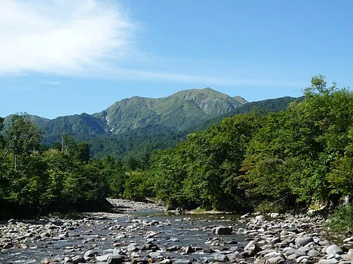 Mount Echigo-Komagatake Mountain, Minamiuonuma18 km E
-
Uono River River, Niigata23 km N
Sources & licences
Data last updated: · 2 independent sources