Aoi-ku
Local name: 葵区
Located in Shizuoka-shi, Shizuoka Coordinates: 35°02′16″ N 138°20′57″ E
- Population
- 255,375
- 255.4K
- Elevation
- 284 m
- above sea level
- Local time
- UTC+09:00
- Asia/Tokyo · UTC+09:00
- Places inside
- 4
- listed under Aoi-ku
- Airports
- FSZ Mount Fuji Shizuoka Airport31 km
- OIM Oshima Airport97 km
About Aoi-ku
Aoi-ku is a municipality. Location: Shizuoka-shi, Shizuoka. Population: 255,375. Elevation: 284 m.
Aoi-ku (葵区, Aoi-ku) is one of three wards of the city of Shizuoka in Shizuoka Prefecture, Japan, located in the northern part of the city. Aoi-ku borders Suruga-ku in the south and Shimizu-ku to the southeast; the west faces Shimada, Fujieda and Kawanehon and its northern tip extends into the border between Nagano Prefecture and Yamanashi Prefecture. It is the largest ward in Japan in terms of geographic area.
Source: Wikipedia · CC BY-SA 4.0
Photos of Aoi-ku
-

Mount Shiomi Alpsdake · Public domain -

Mount Akaishi alpsdake · Public domain -
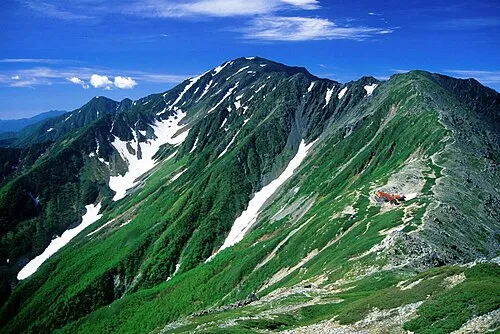
Mount Aino Alpsdake · Public domain


Population of Aoi-ku over time
| 2010 | 255,375 | |
|---|---|---|
| 2015 | 253,593 | |
| 2021 | 247,299 |
Censuses and official estimates; source: Wikidata.
Climate of Aoi-ku
Best months for sightseeingBest months for sightseeing: May–July, September–October.
This month · November
A wet month
Day 16° · Night 7° · Rain 103 mm
Better nearby cities in November
- Fujinomiya · 31 km northeast18°
- Fuji · 34 km northeast20°
- Numazu · 48 km east18°
- Hottest month
- August (day 29°)
- Coldest month
- January (night -1°)
- Wettest month
- June (263 mm)
- Driest month
- December (57 mm)
Bars: average monthly low and high temperature. Below: precipitation. Monthly averages for 1970–2000 at about 18 km resolution, adjusted for elevation. Highlighted months are mild and relatively dry. Source: WorldClim 2.1 (CC BY 4.0).
Show values as a table
| Month | Jan | Feb | Mar | Apr | May | Jun | Jul | Aug | Sep | Oct | Nov | Dec |
|---|---|---|---|---|---|---|---|---|---|---|---|---|
| Average high (°C) | 9° | 9° | 12° | 17° | 21° | 24° | 27° | 29° | 25° | 21° | 16° | 12° |
| Average low (°C) | -1° | 0° | 3° | 8° | 12° | 17° | 20° | 21° | 18° | 13° | 7° | 2° |
| Precipitation (mm) | 62 | 85 | 153 | 184 | 185 | 263 | 220 | 236 | 242 | 161 | 103 | 57 |
Other places to visit in this season: May June July September October
How to get to Aoi-ku
The nearest airport is Mount Fuji Shizuoka Airport (FSZ), 31 km to the southwest as the crow flies. The nearest large city is Shizuoka, 7 km to the southeast.
Airports
- Mount Fuji Shizuoka Airport (FSZ) Makinohara / Shimada 31 kmsouthwest
- Oshima Airport (OIM) Izu Oshima 97 kmeast
- Shinshu-Matsumoto Airport (MMJ) Matsumoto 131 kmnorth
Nearby large cities
- Shizuoka Population: 693.4K 7 kmsoutheast
- Yaizu Population: 139.6K 19 kmsouth
- Fujieda Population: 145K 20 kmsouth
- Fujinomiya Population: 132.5K 31 kmnortheast
- Fuji Population: 245.4K 34 kmnortheast
Straight-line distances; road distances are longer. Airport data: OurAirports.
Day trips from Aoi-ku
Within 100 km: 2 historic and cultural sites, 36 natural sites, 19 lakes, rivers and coasts.
0–25 km2 places
- Abe River River 13 kmS
- Toro Iseki Historic site 11 kmSE
25–60 km21 places
- Lake Shoji Lake 55 kmNE
- Mount Echizen-dake Mountain 46 kmNE
- Suruga Bay Natural site 28 kmSE
- Fuji River River 27 kmE
60–100 km34 places
- Hatsu-shima Island 75 kmE
- Mount Senjō Mountain 77 kmN
- Mount Nokogiri Mountain 83 kmN
- Mount Aino Mountain 68 kmN
Straight-line distances.
Aoi-ku and similar cities
Side by side with cities of similar size in the same country: population, elevation and climate.
| Measure | Aoi-ku | Hiratsuka | Minato | Sōka |
|---|---|---|---|---|
| Population | 255.4K | 258.4K | 260.5K | 249.6K |
| Elevation | 284 m | 8 m | 11 m | 6 m |
| Summer day (hottest month) | 29° | 30° | 30° | 30° |
| Winter night (coldest month) | -1° | 1° | 2° | -1° |
| Annual rainfall | 1,951 mm | 1,729 mm | 1,512 mm | 1,348 mm |
| Best months | May–Jul, Sep–Oct | May–Jun, Oct | May–Jun, Oct | May–Jun, Oct |
| Distance | — | 96 km | 145 km | 159 km |
Climate values are 1970–2000 monthly averages; straight-line distance.
Places in Aoi-ku
4 placesNearby attractions & nature
Everything nearby-
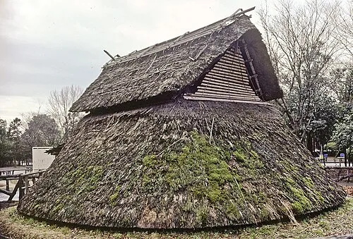 Toro Iseki Historic site, Suruga Ku11 km SE
-
 Abe River River, Shizuoka13 km S
Sources & licences
Data last updated: · 2 independent sources