- Population
- 17,408
- 17.4K
- Elevation
- 273 m
- above sea level
- Local time
- UTC+09:00
- Asia/Tokyo · UTC+09:00
- Places inside
- 2
- listed under Daisen Chō
- Airports
- YGJ Yonago Kitaro Airport / JASDF Miho Air Base27 km
- IZO Izumo Enmusubi Airport58 km
About Daisen Chō
Daisen Chō is a municipality. Location: Saihaku-gun, Tottori. Population: 17,408. Elevation: 273 m.
Daisen (大山町, Daisen-chō) is a town located in Saihaku District, Tottori Prefecture, Japan. As of 31 December 2022, the town had an estimated population of 15,321 in 5630 households and a population density of 81 persons per km2. The total area of the town is 189.83 square kilometres (73.29 sq mi). The town is known for Mount Daisen, the tallest mountain in the Chūgoku Region. The mountain was an early center of Shinto and Buddhist practice, and the town has numerous designated Cultural Properties of Japan.
Source: Wikipedia · CC BY-SA 4.0
Photos of Daisen Chō
-

Mount Daisen kobeoyaji · CC BY 2.1 jp

Travel notes for Daisen Chō
From Wikivoyage
Daisen (大山町 Daisen-chō) is a town in Tottori Prefecture. Mount Daisen is the tallest peak in Western Japan at 1,729 meters, and many outdoor activities are available year-round.
Understand+
Tourist information site:
The local Tourist Bureau has a bilingual guide site.
Get in+
There are 5 stations along the San-in Line in Daisen; Daisenguchi Station, Nawa Station, Mikuriya Station, Shimoichi Station, and Nakayamaguchi Station. All of the stations however are located along the coast, so they do not provide access to Mount Daisen, the town's major draw.
For public access to Mount Daisen, buses depart from Yonago Station. In ski season, there are also direct buses from major regional cities like Okayama.
Source: Wikivoyage · CC BY-SA 4.0 · abridged
Places bordering Daisen Chō
- Yonago
- Hōki Chō
- Kōfu Chō
- Koutara Chō
Twin towns and sister cities of Daisen Chō
- Kure· Japan
- Kadena Chō· Japan
- Iyo· Japan
- Temecula· United States
- Marugame· Japan
Source: Wikidata. Only places with a page on this site are shown.
Population of Daisen Chō over time
| 2010 | 17,491 | |
|---|---|---|
| 2015 | 16,470 | |
| 2021 | 15,336 |
Censuses and official estimates; source: Wikidata.
Climate of Daisen Chō
Best months for sightseeingBest months for sightseeing: May–June, September–October.
This month · November
A wet month
Day 15° · Night 6° · Rain 106 mm
Better nearby cities in November
- Kochi · 212 km south18°
- Ōita · 304 km southwest18°
- Beppu · 305 km southwest17°
- Hottest month
- August (day 30°)
- Coldest month
- February (night -1°)
- Wettest month
- July (247 mm)
- Driest month
- December (97 mm)
Bars: average monthly low and high temperature. Below: precipitation. Monthly averages for 1970–2000 at about 18 km resolution, adjusted for elevation. Highlighted months are mild and relatively dry. Source: WorldClim 2.1 (CC BY 4.0).
Show values as a table
| Month | Jan | Feb | Mar | Apr | May | Jun | Jul | Aug | Sep | Oct | Nov | Dec |
|---|---|---|---|---|---|---|---|---|---|---|---|---|
| Average high (°C) | 6° | 6° | 10° | 17° | 21° | 24° | 28° | 30° | 25° | 20° | 15° | 9° |
| Average low (°C) | -1° | -1° | 1° | 7° | 11° | 16° | 21° | 22° | 17° | 11° | 6° | 1° |
| Precipitation (mm) | 111 | 111 | 116 | 131 | 139 | 212 | 247 | 159 | 224 | 127 | 106 | 97 |
Other places to visit in this season: May June September October
How to get to Daisen Chō
The nearest airport is Yonago Kitaro Airport / JASDF Miho Air Base (YGJ), 27 km to the west as the crow flies. The nearest large city is Yonago, 18 km to the west.
Airports
- Yonago Kitaro Airport / JASDF Miho Air Base (YGJ) Yonago 27 kmwest
- Izumo Enmusubi Airport (IZO) Izumo 58 kmwest
- Tottori Sand Dunes Conan Airport (TTJ) Tottori 58 kmeast
Nearby large cities
- Yonago Population: 148.7K 18 kmwest
- Matsue Population: 203.6K 43 kmwest
- Tsuyama Population: 102.3K 62 kmsoutheast
- Tottori-shi Population: 188.5K 64 kmeast
- Izumo Population: 172.8K 70 kmwest
Straight-line distances; road distances are longer. Airport data: OurAirports.
Day trips from Daisen Chō
Within 100 km: 3 historic and cultural sites, 11 natural sites, 14 lakes, rivers and coasts.
0–25 km3 places
- Hino River River 14 kmW
- Miho Bay Natural site 18 kmW
- Mount Daisen Mountain 9 kmS
25–60 km10 places
- Daikon Island Island 32 kmW
- Shinji Ko Lake 52 kmW
- Lake Nakaumi Lake 30 kmW
- Mount Sentsū Mountain 46 kmSW
60–100 km15 places
- Oki Islands Island 92 kmN
- Sendai River River 61 kmE
- Tottori Castle ruins Historic site 65 kmE
- Mount Hyōno Mountain 90 kmE
Straight-line distances.
Places in Daisen Chō
2 placesMikuriya
Population: 15.4K
-
Nearby attractions & nature
Everything nearby-
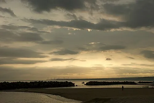 Miho Bay Natural site, Tottori18 km W
-
Hino River River, Tottori14 km W
Sources & licences
Data last updated: · 2 independent sources