Puerto del Rosario
Located in Las Palmas, Canary Islands Coordinates: 28°30′38″ N 13°57′22″ W
- Population
- 36,285
- 36.3K
- Elevation
- 419 m
- above sea level
- Local time
- UTC+00:00
- Atlantic/Canary · UTC+00:00
- Places inside
- 32
- listed under Puerto del Rosario
- Airports
- FUE Fuerteventura Airport11 km
- ACE César Manrique-Lanzarote Airport59 km
About Puerto del Rosario
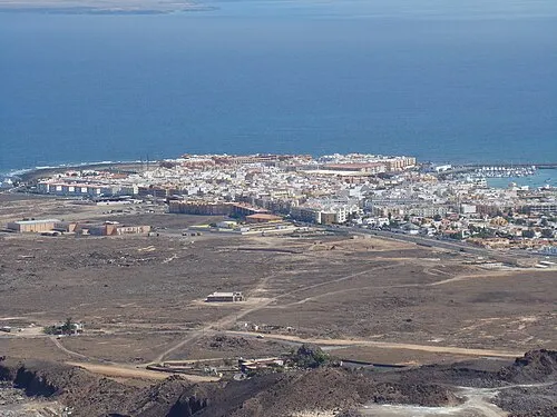
Puerto del Rosario is a municipality. Location: Las Palmas, Canary Islands. Population: 36,285. Elevation: 419 m. The best months to visit are March–November. The nearest airport is Fuerteventura Airport (11 km). Nearby sights include Montaña Tindaya and Valle de Fimapaire.
Climate of Puerto del Rosario
Best months for sightseeingBest months for sightseeing: March–November.
This month · November
A good month to visit
Day 22° · Night 14° · Rain 21 mm
- Hottest month
- August (day 27°)
- Coldest month
- January (night 11°)
- Wettest month
- December (31 mm)
- Driest month
- July (0 mm)
Bars: average monthly low and high temperature. Below: precipitation. Monthly averages for 1970–2000 at about 18 km resolution, adjusted for elevation. Highlighted months are mild and relatively dry. Source: WorldClim 2.1 (CC BY 4.0).
Show values as a table
| Month | Jan | Feb | Mar | Apr | May | Jun | Jul | Aug | Sep | Oct | Nov | Dec |
|---|---|---|---|---|---|---|---|---|---|---|---|---|
| Average high (°C) | 19° | 19° | 21° | 21° | 22° | 24° | 26° | 27° | 26° | 24° | 22° | 20° |
| Average low (°C) | 11° | 12° | 12° | 13° | 14° | 16° | 18° | 18° | 18° | 16° | 14° | 13° |
| Precipitation (mm) | 22 | 22 | 16 | 7 | 2 | 1 | 0 | 1 | 5 | 9 | 21 | 31 |
Other places to visit in this season: March April May June July August September October November
How to get to Puerto del Rosario
The nearest airport is Fuerteventura Airport (FUE), 11 km to the southeast as the crow flies. The nearest large city is Las Palmas de Gran Canaria, 150 km to the west.
Airports
- Fuerteventura Airport (FUE) El Matorral 11 kmsoutheast
- César Manrique-Lanzarote Airport (ACE) San Bartolomé 59 kmnortheast
- Gran Canaria Airport (LPA) Gran Canaria Island 154 kmsouthwest
Nearby large cities
- Las Palmas de Gran Canaria Population: 383.5K 150 kmwest
- Telde Population: 123.3K 155 kmwest
- Santa Cruz de Tenerife Population: 211.4K 225 kmwest
- San Cristóbal de La Laguna Population: 150.7K 231 kmwest
Straight-line distances; road distances are longer. Airport data: OurAirports.
Day trips from Puerto del Rosario
Within 100 km: 75 historic and cultural sites, 101 natural sites, 96 lakes, rivers and coasts.
0–25 km77 places
- Fuerteventura Island 16 kmSW
- Playa La Cabezuela Beach 18 kmNE
- Montaña de Tao Mountain 4 kmSW
- Monte Muda Mountain 7 kmN
25–60 km95 places
- Playa de Sotavento de Jandía Beach 55 kmSW
- Playa de Matagorda Beach 58 kmNE
- Fariones Playa Beach 54 kmNE
- Playa Dorada Beach 41 kmN
60–100 km100 places
- Lanzarote Island 63 kmNE
- Graciosa Island 93 kmNE
- Playa de las Conchas Beach 95 kmNE
- Playa Del Risco Beach 90 kmNE
Straight-line distances.
Places in Puerto del Rosario
32 placesBar: population relative to the most populous place in this list.
Cities & villages12
- Casillas del Ángel · Village
- El Matorral · Village
- El Time · Village
- Guisguey · Village
- La Ampuyenta · Village
- Llanos de la Concepción · Village
- Puerto de las Lajas · Village
- Tamariche · Village
- Tefía · Village
- Tetir · Village
- Valhondo · Village
- Vallebrón · Village
Mountains & nature5
- Loma de Salinas · Mountain
- Montaña de Tao · Mountain
- Monte Muda · Mountain
- Pico de la Fortaleza · Mountain
- Puerto del Rosario · Natural site
Lakes, rivers & coasts5
- Los Hornos · Beach
- Playa Blanca · Beach
- Playa de Jarubio · Beach
- Playa de la Mujer · Beach
- Playa Las Lajas · Beach
Heritage & sights8
- Auditorio Insular de Fuerteventura · Attraction
- Casa de la Cultura de Puerto del Rosario · Attraction
- Casa museo Unamuno · Museum
- Centro de Arte Juan Ismael · Museum
- Ecomuseo La Alcogida · Museum
- Ermita de San Juan · Attraction
- Faro de Punta Gaviota · Landmark
- Iglesia Nuestra Señora del Rosario · Attraction
Nearby attractions & nature
Everything nearby-
Montaña Tindaya Mountain, Oliva, La9.7 km N
-
Valle de Fimapaire Natural site, Oliva, La12 km NE
-
Windmill at Cactus Garden Historic site, Antigua10 km SW
-
Cactus Garden Attraction, Antigua10 km SW
-
Museo del Queso Majorero Museum, Antigua11 km SW
-
Playa de Tebeto Beach, Oliva, La12 km NW
-
Casa de Los Coroneles Historic site, Oliva, La11 km N
-
Ermita Nuestra Señora de Puerto Attraction, Oliva, La11 km N
Other cities and towns in Las Palmas
Sources & licences
Data last updated: