- Population
- 22,834
- 22.8K
- Elevation
- 261 m
- above sea level
- Local time
- UTC+09:00
- Asia/Tokyo · UTC+09:00
- Airports
- HIJ Hiroshima Airport34 km
- IWK Iwakuni Kintaikyo Airport36 km
About Kumano
Kumano is a town. Location: Kumano-chō, Aki-gun. Population: 22,834. Elevation: 261 m. The best months to visit are May–June, September–October. The nearest airport is Hiroshima Airport (34 km). Nearby sights include Carp castle and Mount Noro.
Climate of Kumano
Best months for sightseeingBest months for sightseeing: May–June, September–October.
This month · November
Outside the best season
Day 16° · Night 7° · Rain 82 mm
Better nearby cities in November
- Kochi · 124 km southeast18°
- Ōita · 152 km southwest18°
- Beppu · 153 km southwest17°
- Hottest month
- August (day 30°)
- Coldest month
- January (night 1°)
- Wettest month
- June (293 mm)
- Driest month
- December (45 mm)
Bars: average monthly low and high temperature. Below: precipitation. Monthly averages for 1970–2000 at about 18 km resolution, adjusted for elevation. Highlighted months are mild and relatively dry. Source: WorldClim 2.1 (CC BY 4.0).
Show values as a table
| Month | Jan | Feb | Mar | Apr | May | Jun | Jul | Aug | Sep | Oct | Nov | Dec |
|---|---|---|---|---|---|---|---|---|---|---|---|---|
| Average high (°C) | 8° | 8° | 12° | 17° | 22° | 25° | 29° | 30° | 26° | 21° | 16° | 11° |
| Average low (°C) | 1° | 1° | 3° | 9° | 13° | 18° | 22° | 23° | 19° | 13° | 7° | 3° |
| Precipitation (mm) | 55 | 76 | 120 | 167 | 176 | 293 | 244 | 179 | 222 | 127 | 82 | 45 |
Other places to visit in this season: May June September October
How to get to Kumano
The nearest airport is Hiroshima Airport (HIJ), 34 km to the east as the crow flies. The nearest large city is Kure, 11 km to the south.
Airports
- Hiroshima Airport (HIJ) Hiroshima 34 kmeast
- Iwakuni Kintaikyo Airport (IWK) Iwakuni 36 kmsouthwest
- Matsuyama Airport (MYJ) Matsuyama 57 kmsouth
Nearby large cities
- Kure Population: 214.6K 11 kmsouth
- Hiroshima Population: 1.2M 13 kmnorthwest
- Higashihiroshima Population: 196.6K 18 kmnortheast
- Hatsukaichi Population: 114.2K 22 kmwest
- Iwakuni Population: 129.1K 37 kmsouthwest
Straight-line distances; road distances are longer. Airport data: OurAirports.
Day trips from Kumano
Within 100 km: 5 historic and cultural sites, 10 natural sites, 26 lakes, rivers and coasts.
0–25 km7 places
- Kurahashi-jima Island 24 kmS
- Kurahashi Jima Island 23 kmS
- Nino Shima Island 13 kmW
- Mount Noro Mountain 12 kmSE
25–60 km17 places
- Ikuchi Jima Island 50 kmE
- Ōmi Shima Island 42 kmE
- Itsuku Shima Island 25 kmW
- Hashira Island Island 38 kmS
60–100 km17 places
- Ao Island Island 67 kmS
- Manabe Island Island 93 kmE
- Ise Jima Island 80 kmNW
- Eno-kawa River 83 kmN
Straight-line distances.
Nearby attractions & nature
Everything nearby-
 Carp castle Historic site, Naka-ku13 km NW
-
Mount Noro Mountain, Kure12 km SE
-
 Nino Shima Island, Hiroshima13 km W
-
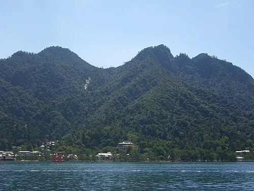 Mont Misen Mountain, Hatsukaichi-shi24 km W
-
Ota River River, Japan15 km W
-
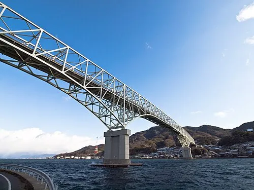 Kurahashi Jima Island, Hiroshima23 km S
-
Kurahashi-jima Island, Japan24 km S
Sources & licences
Data last updated: