Wakkanai
Local name: 稚内市
Located in Wakkanai Shi, Hokkaido Coordinates: 45°24′34″ N 141°40′26″ E
- Population
- 33,869
- 33.9K
- Elevation
- 7 m
- above sea level
- Local time
- UTC+09:00
- Asia/Tokyo · UTC+09:00
- Airports
- WKJ Wakkanai Airport10 km
- RIS Rishiri Airport43 km
About Wakkanai
Wakkanai is a city. Location: Wakkanai Shi, Hokkaido. Population: 33,869. Elevation: 7 m.
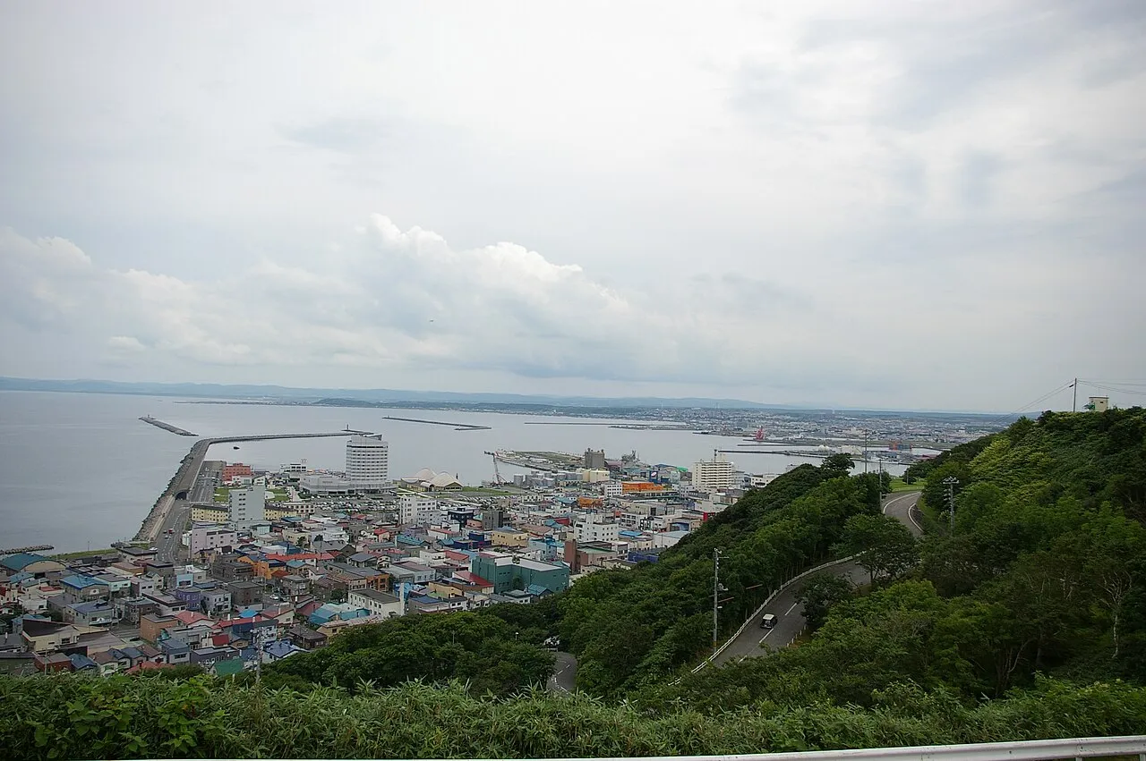
Wakkanai (稚内市, Wakkanai-shi; Ainu: ヤㇺワッカナィ Yam-wakka-nay meaning "cold water river" or more literally "cold river valley") is a city located in Sōya Subprefecture, Hokkaido, Japan. Wakkanai is the capital of Sōya Subprefecture. Situated approximately 1,100 km north of Tokyo and 270 km north of Sapporo, it is the northernmost municipality under Japanese administration following the loss of Karafuto (present-day Sakhalin) and the Kuril Islands, with Benten-jima being the northernmost point under Japanese control.
Source: Wikipedia · CC BY-SA 4.0
Photos of Wakkanai
-

Ryo FUKAsawa from Tokyo, Japan · CC BY 2.0 -

IRishikawa521 · CC BY-SA 3.0 -

Ryo FUKAsawa from Tokyo, Japan · CC BY 2.0 -

Ryo FUKAsawa · CC BY 2.0 -

Ryo FUKAsawa · CC BY 2.0


Travel notes for Wakkanai
From Wikivoyage
Wakkanai (稚内) is the northernmost city in Japan. It has a population of about 34,000 (2019), and is in the subdistrict of Soya in northern Hokkaido. It is the gateway to Rishiri-Rebun-Sarobetsu National Park, Japan's northernmost national park.
Understand+
History:
The city was established in the 17th century as a frontier trading post to the aboriginal Ainu people who used to inhabit much of Hokkaido. It prospered through trade and as a strategic outpost in the far flung northern reaches of the empire, in the century that followed. The modern city was established in 1900, and when Japan recaptured parts of Sakhalin Island after the Russo-Japanese war of 1905, it became the main transit point to the Karafuto prefecture established there with regular steam-liner operations to Otomari (today Korsakov), a status that only increased when the Sōya railway was finally extended here in 1926. With the loss of Sakhalin in the aftermath of World War II, the town's fortunes faded; it reverted to being little more than a military post during the Cold War, home to some American troops.
While the population is still dwindling, the end of the Cold War might change Wakkanai's fortunes once more: a regular ferry route to Sakhalin was reopened in the 1990s, and trade and ties with Russia are slowly but steadily increasing.
Climate:
The average summer temperature is around 20°C (68°F), but it can get cold at night, so you may need to bring more than a summer jacket. In the depths of winter the thermometer frequently drops below zero, but the −20°C (-4°F) you see inland or across the Okhotsk bay in Russia are extreme occurrences here, as the air is heated by sea currents. The very strong winds can make it feel like Siberia, though.
Tourist information site:
The city government's official site has a good Japanese-only tourism section.
The local tourist associations has a Japanese-only guide site, covering Rishri and Rebun islands too. (Clicking on "languages" lead to the prefecture's multilingual site.)
Get in+
By plane:
1 Wakkanai Airport (WKJ IATA) (10 km (6.2 mi) southeast of the city). It fields regular flights from Sapporo and Tokyo (Haneda), with additional summer-only services from Nagoya and Kansai. All flights to the airport are operated by ANA - All Nippon Airways. The airport is 20 minutes away from Wakkanai station by bus.
By train:
The JR Soya Main Line (Soya Honsen) connects Wakkanai to Asahikawa. There are two stations within the city limits: 2 Wakkanai(station code W80) and 3 Minami-Wakkanai(W79) to the south.
Wakkanai sees limited train service, with only six arrivals and seven departures per day. Of these, three round-trips are limited express services: The once-daily Soya which runs directly to and from Sapporo (5 hr 10 min, ¥10,450), and the twice-daily Sarobetsu to and from Asahikawa (3 hr 45 min, ¥8,300, change to either a Lilac or Kamui limited express service at Asahikawa for Sapporo). There are no extra charges for these trains with the Japan Rail Pass and / or Hokkaido Rail Pass.
By bus:
Several buses operated by Soya Bus run between Wakkanai and Sapporo daily: the journey takes around 6 hours and costs ¥6000, advance ticket purchase or reservation is (at least in theory) necessary, ☏ +81 011 241-0241 (Sapporo) or ☏ +81 0162 22-3114 (Wakkanai) to make your reservation. One of the departures is a red-eye service, which might be a useful way to save some money if you're one of those who can sleep anywhere. There is also a single daily round trip to Asahikawa. While this is a cheap and convenient option in summer, during the winter suspension or delays are commonplace, and snowstorms frequently close the highway altogether.
By boat:
The ferry terminal, directly east of the train station, hosts frequent (in summer) connections to the National Park islands of Rebun and Rishiri; there are also a few shops and restaurants and a tourist information desk in the building.
All ferries out of Wakkanai are operated by the Heartland Ferry Company.
Source: Wikivoyage · CC BY-SA 4.0 · abridged
Places bordering Wakkanai
- Sarufutsu Mura
- Toyotomi
Twin towns and sister cities of Wakkanai
- Ishigaki-shi· Japan
- Makurazaki· Japan
Source: Wikidata. Only places with a page on this site are shown.
Population of Wakkanai over time
| 2010 | 39,595 | |
|---|---|---|
| 2015 | 36,380 | |
| 2020 | 33,036 |
Censuses and official estimates; source: Wikidata.
Climate of Wakkanai
Best months for sightseeingBest months for sightseeing: July–September.
This month · November
A wet month
Day 6° · Night 0° · Rain 122 mm
- Hottest month
- August (day 22°)
- Coldest month
- February (night -9°)
- Wettest month
- October (133 mm)
- Driest month
- April (54 mm)
Bars: average monthly low and high temperature. Below: precipitation. Monthly averages for 1970–2000 at about 18 km resolution, adjusted for elevation. Highlighted months are mild and relatively dry. Source: WorldClim 2.1 (CC BY 4.0).
Show values as a table
| Month | Jan | Feb | Mar | Apr | May | Jun | Jul | Aug | Sep | Oct | Nov | Dec |
|---|---|---|---|---|---|---|---|---|---|---|---|---|
| Average high (°C) | -5° | -4° | 1° | 7° | 13° | 16° | 20° | 22° | 19° | 14° | 6° | -1° |
| Average low (°C) | -9° | -9° | -5° | 1° | 5° | 10° | 14° | 17° | 13° | 7° | 0° | -5° |
| Precipitation (mm) | 92 | 61 | 56 | 54 | 66 | 62 | 89 | 114 | 120 | 133 | 122 | 114 |
How to get to Wakkanai
The nearest airport is Wakkanai Airport (WKJ), 10 km to the east as the crow flies. For international flights: Yuzhno-Sakhalinsk International Airport (UUS) (183 km). The nearest large city is Asahikawa, 190 km to the south.
Airports
- Wakkanai Airport (WKJ) Wakkanai 10 kmeast
- Rishiri Airport (RIS) Rishiri 43 kmsouthwest
- Yuzhno-Sakhalinsk International Airport (UUS) Yuzhno-Sakhalinsk 183 kmnortheast
Nearby large cities
- Asahikawa Population: 333.5K 190 kmsouth
- Kitami Population: 119.1K 251 kmsoutheast
- Otaru Population: 115.3K 252 kmsouth
- Ebetsu Population: 134K 256 kmsouth
- Sapporo Population: 2M 262 kmsouth
Straight-line distances; road distances are longer. Airport data: OurAirports.
Day trips from Wakkanai
Within 100 km: 4 natural sites, 5 lakes, rivers and coasts.
0–25 km4 places
- Koetoi River River 6 kmE
- Sōya Bay Natural site 8 kmNE
- Benten-jima Island 23 kmNE
- Cape Soya Natural site 24 kmNE
25–60 km5 places
- Rishiri Tō Island 42 kmSW
- Rebun Tō Island 50 kmW
- Rishiri Zan Mountain 42 kmSW
- Rebun Dake Mountain 52 kmW
Straight-line distances.
Nearby attractions & nature
Everything nearby-
 Koetoi River River, Hokkaido6.4 km E
-
Sōya Bay Natural site, Hokkaido8.4 km NE
-
 Cape Soya Natural site, Wakkanai Shi24 km NE
-
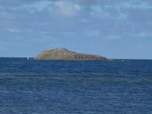 Benten-jima Island, Hokkaido23 km NE
Sources & licences
Data last updated: · 2 independent sources