
- Elevation
- 300 m
- above sea level
- Local time
- UTC+09:00
- Asia/Tokyo · UTC+09:00
- Airports
- TAK Takamatsu Airport40 km
- OKJ Okayama Momotaro Airport47 km
About Shōdo Island
Shōdo Island is an island. Location: Shōdoshima Chō, Shōzu-gun.
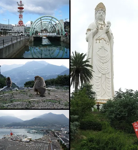
Shōdoshima or Shōdo Island (小豆島, Shōdoshima) is an island located in the Inland Sea of Japan. The name means "Island of Small Beans". There are two towns on the island: Tonoshō and Shōdoshima, composing the district of Shōzu. The island is famous as the setting for the novel Twenty-Four Eyes and its subsequent film adaptations and the manga Teasing Master Takagi-san and its adaptations. The island was the first area of Japan to successfully grow olives, and it is sometimes known as "Olive Island".
Source: Wikipedia · CC BY-SA 4.0
Photos of Shōdo Island
-

Wei-Te Wong from Taipei City, Taiwan, Republic of China · CC BY-SA 2.0 -

おにく · CC0 -

米田賢? · CC BY 3.0 -

Maarten Heerlien from The Hague, The Netherlands · CC BY 2.0 -

Maarten Heerlien from Voorschoten, The Netherlands · CC BY 2.0


Travel notes for Shōdo Island
From Wikivoyage
Shōdo Island (小豆島 / Shōdo-shima) is an island in Kagawa, Japan. It is the second largest island in the Seto Inland Sea.
Understand+
The name Shōdoshima literally means "island of small beans". There are 2 towns on the island: Tonoshō (土庄) and Shodoshima Town. Along with Teshima, the island comprises Shozu District in Kagawa.
Shōdoshima is famous as the setting for the 1954 antiwar movie Twenty-Four Eyes (二十四の瞳 / Nijūshi no Hitomi). The movie is based on a book written in 1952 by Sakae Tsuboi (1899-1967), who was born on Shōdoshima.
In 1908, the island became the first in Japan to successfully cultivate olives. Olive trees proliferate on the island and olive-related merchandise is quite popular with tourists.
Shōdoshima is also known for its soy sauce, wild monkeys, and beaches.
Shinto legend:
According to Shinto legend, Shōdoshima was one of the first islands created by the gods.
Tourist Information Site:
The local tourist association has a Japanese-only guide site with integrated Google Translate.
Get in+
By boat:
Shōdoshima can be reached by boat from Uno Port in Tamano (90 minutes, ¥1,230), Shin-Okayama Port near Okayama (70 minutes, ¥1,050), Kobe (3.5 hours, ¥1,990), Himeji (100 minutes, ¥1,520), or Takamatsu on the island of Shikoku (60 minutes, ¥690 for ferry or 30 minutes, ¥1,170 for a speed boat).
List of ferries to Shodoshima is available online (Japanese).
Source: Wikivoyage · CC BY-SA 4.0 · abridged
Climate of Shōdo Island
Best months for sightseeingBest months for sightseeing: May–June, September–October.
This month · November
Outside the best season
Day 14° · Night 7° · Rain 73 mm
Better nearby cities in November
- Kochi · 126 km southwest18°
- Ōita · 284 km southwest18°
- Beppu · 290 km southwest17°
- Hottest month
- August (day 29°)
- Coldest month
- January (night -1°)
- Wettest month
- September (234 mm)
- Driest month
- December (31 mm)
Bars: average monthly low and high temperature. Below: precipitation. Monthly averages for 1970–2000 at about 18 km resolution, adjusted for elevation. Highlighted months are mild and relatively dry. Source: WorldClim 2.1 (CC BY 4.0).
Show values as a table
| Month | Jan | Feb | Mar | Apr | May | Jun | Jul | Aug | Sep | Oct | Nov | Dec |
|---|---|---|---|---|---|---|---|---|---|---|---|---|
| Average high (°C) | 7° | 7° | 10° | 16° | 21° | 24° | 28° | 29° | 25° | 20° | 14° | 9° |
| Average low (°C) | -1° | -1° | 2° | 7° | 12° | 17° | 21° | 22° | 18° | 12° | 7° | 2° |
| Precipitation (mm) | 40 | 55 | 93 | 146 | 153 | 232 | 201 | 130 | 234 | 115 | 73 | 31 |
Other places to visit in this season: May June September October
How to get to Shōdo Island
The nearest airport is Takamatsu Airport (TAK), 40 km to the southwest as the crow flies. The nearest large city is Takamatsu, 28 km to the southwest.
Airports
- Takamatsu Airport (TAK) Takamatsu 40 kmsouthwest
- Okayama Momotaro Airport (OKJ) Okayama 47 kmnorthwest
- Tokushima Awaodori Airport / JMSDF Tokushima Air Base (TKS) Tokushima 52 kmsoutheast
Nearby large cities
- Takamatsu Population: 419K 28 kmsouthwest
- Kurashiki Population: 483.6K 47 kmwest
- Marugame Population: 109.5K 51 kmsouthwest
- Himeji Population: 530.5K 52 kmnortheast
- Tokushima Population: 267.3K 56 kmsoutheast
Straight-line distances; road distances are longer. Airport data: OurAirports.
Day trips from Shōdo Island
Within 100 km: 12 historic and cultural sites, 14 natural sites, 25 lakes, rivers and coasts.
0–25 km6 places
- Te Shima Island 18 kmW
- Ogi Shima Island 21 kmSW
- Megi Shima Island 24 kmSW
- Yashima Natural site 22 kmSW
25–60 km22 places
- Awaji Island Island 53 kmE
- Nao Shima Island 27 kmW
- Shiwaku Islands Island 52 kmW
- Ibo Gawa River 41 kmNE
60–100 km23 places
- Mount Rokkō Mountain 96 kmE
- Manabe Island Island 65 kmW
- Tomoga Shima Island 74 kmE
- Osaka Bay Natural site 80 kmE
Straight-line distances.
Nearest towns and villages
-
Tonosho-cho Municipality, Shōzu-gun6.4 km W
-
Ikeda Village, Shōdoshima Chō4.2 km SW
-
 Tonoshō Town, Tonosho-cho9.3 km W
-
Shido Town, Sanuki-shi22 km SW
-
Setouchi City, Setouchi Shi20 km NW
-
 HIgashi-ku Municipality, Okayama Shi27 km NW
Nearby attractions & nature
Everything nearby-
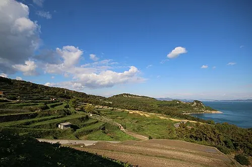 Te Shima Island, Kagawa18 km W
-
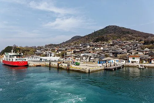 Ogi Shima Island, Kagawa21 km SW
-
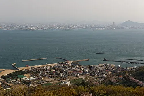 Megi Shima Island, Kagawa24 km SW
-
Inujima Island, Okayama16 km W
-
Yashima Natural site, Kagawa22 km SW
-
Yoshii River River, Okayama24 km NW
Sources & licences
Data last updated: · 2 independent sources