Zamami Village
Local name: 座間味村
Located in Shimajiri-gun, Okinawa Coordinates: 26°12′02″ N 127°17′02″ E
- Population
- 900
- 900
- Elevation
- 101 m
- above sea level
- Local time
- UTC+09:00
- Asia/Tokyo · UTC+09:00
- Places inside
- 1
- listed under Zamami Village
- Airports
- OKA Naha International Airport36 km
- UEO Kumejima Airport60 km
About Zamami Village
Zamami Village is a municipality. Location: Shimajiri-gun, Okinawa. Population: 900. Elevation: 101 m.
Zamami (座間味村, Zamami-son; Okinawan: Kushigiruma (後慶留間)) is a village located in Shimajiri District, Okinawa Prefecture, Japan. The village consists of more than 20 islands approximately 40 kilometres (25 mi) west of the prefectural capital of Naha. As of October 2020 the village had a population of 892 and a population density of 53.29 persons per km2. The total area of the village of Zamami is 16.74 square kilometres (6.46 mi2).
Source: Wikipedia · CC BY-SA 4.0
Photos of Zamami Village
-

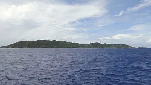
Kerama Islands Robdav69 · CC BY-SA 3.0

Population of Zamami Village over time
| 2010 | 865 | |
|---|---|---|
| 2015 | 870 | |
| 2021 | 891 |
Censuses and official estimates; source: Wikidata.
Climate of Zamami Village
Best months for sightseeingBest months for sightseeing: November–May.
This month · November
A good month to visit
Day 24° · Night 20° · Rain 135 mm
- Hottest month
- July (day 31°)
- Coldest month
- February (night 15°)
- Wettest month
- August (252 mm)
- Driest month
- December (111 mm)
Bars: average monthly low and high temperature. Below: precipitation. Monthly averages for 1970–2000 at about 18 km resolution, adjusted for elevation. Highlighted months are mild and relatively dry. Source: WorldClim 2.1 (CC BY 4.0).
Show values as a table
| Month | Jan | Feb | Mar | Apr | May | Jun | Jul | Aug | Sep | Oct | Nov | Dec |
|---|---|---|---|---|---|---|---|---|---|---|---|---|
| Average high (°C) | 19° | 19° | 21° | 23° | 25° | 29° | 31° | 30° | 29° | 27° | 24° | 21° |
| Average low (°C) | 15° | 15° | 17° | 19° | 22° | 25° | 26° | 26° | 25° | 23° | 20° | 17° |
| Precipitation (mm) | 133 | 130 | 176 | 183 | 239 | 245 | 176 | 252 | 216 | 174 | 135 | 111 |
Other places to visit in this season: January February March April May November December
How to get to Zamami Village
The nearest airport is Naha International Airport (OKA), 36 km to the east as the crow flies. The nearest large city is Naha, 39 km to the east.
Airports
- Naha International Airport (OKA) Naha 36 kmeast
- Kumejima Airport (UEO) Kumejima 60 kmwest
- Yoron Airport (RNJ) Yoron 145 kmnortheast
Nearby large cities
- Naha Population: 317.6K 39 kmeast
- Urasoe Population: 115.7K 45 kmeast
- Ginowan Population: 100.1K 48 kmeast
- Okinawa Population: 142.8K 54 kmeast
- Uruma Population: 125.3K 61 kmeast
Straight-line distances; road distances are longer. Airport data: OurAirports.
Day trips from Zamami Village
Within 100 km: 1 historic or cultural site, 7 natural sites, 18 lakes, rivers and coasts.
0–25 km8 places
- Kerama Islands Island 5 kmE
- Zamami Island Island 5 kmNE
- Aka Island Island 1 kmW
- Fukaji Island Island 4 kmS
25–60 km5 places
- Kume Jima Island 54 kmW
- Kokuba Gawa River 40 kmE
- Irisuna-jima Island 27 kmNW
- Aguni Island Island 43 kmN
60–100 km13 places
- Iejima Island Island 77 kmNE
- Okinawa Island 74 kmNE
- Okinawa Islands Island 93 kmNE
- Minna Shima Island 73 kmNE
Straight-line distances.
Places in Zamami Village
1 placeBar: population relative to the most populous place in this list.
Nearby attractions & nature
Everything nearby-
Aka Island Island, Okinawa0.5 km W
-
Geruma Island Island, Okinawa2.1 km S
-
Fukaji Shima Island, Okinawa3.7 km S
-
Zamami Island Island, Okinawa4.5 km NE
-
Kerama Islands Island, Okinawa4.6 km E
-
Fukaji Island Island, Japan3.7 km S
-
Tokashiki Jima Island, Okinawa7 km E
-
 Mae Shima Island, Okinawa16 km E
Other cities and towns in Shimajiri-gun
-
Kumejima Town Municipality, Shimajiri-gun55 km W
-
Yaese Town Municipality, Shimajiri-gun45 km E
-
Aguni Village Municipality, Shimajiri-gun43 km N
-
Izena Village Municipality, Shimajiri-gun104 km NE
-
 Yaese Town, Yaese Town47 km E
-
Iheya Village Municipality, Shimajiri-gun116 km NE
Sources & licences
Data last updated: · 2 independent sources