
- Population
- 16,363
- 16.4K
- Elevation
- 20 m
- above sea level
- Local time
- UTC+09:00
- Asia/Tokyo · UTC+09:00
- Airports
- SDJ Sendai Airport29 km
- GAJ Yamagata Airport60 km
About Matsushima
Matsushima is a town. Location: Matsushima Machi, Miyagi Gun. Population: 16,363. Elevation: 20 m. The best months to visit are May–October. The nearest airport is Sendai Airport (29 km). Nearby sights include Zuigan Ji and Matsushima Guntō.
Photos of Matsushima
-

Real Estate Japan from Tokyo, Japan · CC BY 2.0 -

Maarten Heerlien from Voorschoten, The Netherlands · CC BY 2.0 -
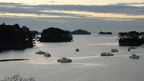
Matsushima Guntō Chensiyuan · CC BY-SA 4.0 -
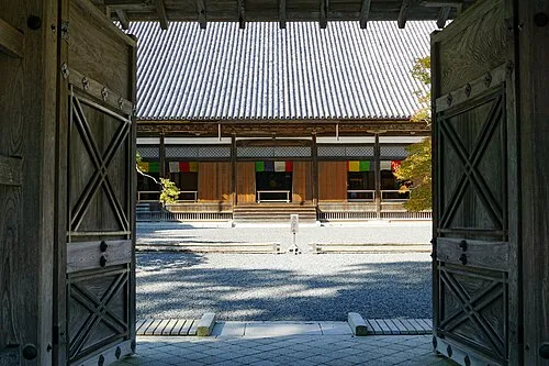
Zuigan Ji 663highland · CC BY-SA 4.0


Travel notes for Matsushima
From Wikivoyage
Matsushima (松島) is a small town in Miyagi prefecture, northeastern Japan. The town faces Matsushima Bay, famous for some 260 tiny islands (島 shima) covered in pines (松 matsu) — hence the name — and ranked as one of Japan's Three Great Views.
Understand+
In 1689, haiku poet Matsuo Basho visited Matsushima on the trip recorded in Narrow Road to the Deep North. A well-known poem often (but, alas, falsely) attributed to Basho claims to record his reaction, signifying that nothing more could be said:
Today's Matsushima is perhaps a little less inspiring, but still a worthwhile day trip if in the region.
The town did not suffer significant damage due to the Great East Japan Earthquake; the tsunami damage was minimal. The temples, shrines, and sights are still there and still worth the trip.
Tourist information site:
The local tourist association has a multilingual guide site.
Get in+
The town is only a short distance from prefectural capital Sendai.
By train:
Most visitors arrive on the JR Senseki Line (仙石線) connecting Sendai and Ishinomaki. The most convenient station is Matsushima-Kaigan (松島海岸), which is 40 minutes from Sendai (¥420). During daytime hours there are usually only two departures per hour to Matsushima-Kaigan. Another hourly service runs as far as Hon-Shiogama (see below). If you buy a ticket in Sendai, be sure to have the name written in characters: the machines do not have an English option.
On the other hand, Matsushima station on the JR Tohoku Main Line is further away from the shore and requires a walk of at least 20 minutes, or a short taxi ride, to reach the ferry.
From Tokyo, the Shinkansen bullet train runs to Sendai for connection to the Senseki Line. The total one-way fare is ¥11,520 using the fastest, all-reserved Shinkansen service, and the journey to Matsushima-Kaigan lasts around 2 hr 45 min. There is no charge if you use the Japan Rail Pass.
By boat:
Ferries tour around the islands every half hour or so, and some of them do the trip to and from Hon-Shiogama on the JR Senseki line (don't mistake it with JR Tohoku line train to Shiogama station). The ferries are focused on sightseeing, and you won't miss any of the islands in the bay by taking the ferry to Hon-Shiogama. If you are flexible, you can do this trip on your return leg, as it is much more pleasant to be waiting at the wharf in Matsushima than at Hon-Shiogama (although the latter does have an air-conditioned waiting room, and a cafe).
From Hon-Shiogama train station to the wharf is a 500-m walk. You can see one from the other, or follow the signs.
Source: Wikivoyage · CC BY-SA 4.0 · abridged
Climate of Matsushima
Best months for sightseeingBest months for sightseeing: May–October.
This month · November
Outside the best season
Day 13° · Night 4° · Rain 66 mm
Better nearby cities in November
- Isehara · 366 km southwest18°
- Kofu · 374 km southwest17°
- Odawara · 386 km southwest19°
- Hottest month
- August (day 27°)
- Coldest month
- January (night -3°)
- Wettest month
- September (170 mm)
- Driest month
- January (40 mm)
Bars: average monthly low and high temperature. Below: precipitation. Monthly averages for 1970–2000 at about 18 km resolution, adjusted for elevation. Highlighted months are mild and relatively dry. Source: WorldClim 2.1 (CC BY 4.0).
Show values as a table
| Month | Jan | Feb | Mar | Apr | May | Jun | Jul | Aug | Sep | Oct | Nov | Dec |
|---|---|---|---|---|---|---|---|---|---|---|---|---|
| Average high (°C) | 4° | 5° | 8° | 14° | 18° | 21° | 25° | 27° | 23° | 18° | 13° | 7° |
| Average low (°C) | -3° | -3° | 0° | 5° | 10° | 15° | 19° | 21° | 17° | 10° | 4° | -1° |
| Precipitation (mm) | 40 | 50 | 67 | 93 | 98 | 126 | 146 | 136 | 170 | 113 | 66 | 40 |
Other places to visit in this season: May June July August September October
How to get to Matsushima
The nearest airport is Sendai Airport (SDJ), 29 km to the southwest as the crow flies. The nearest large city is Sendai, 21 km to the southwest.
Airports
- Sendai Airport (SDJ) Natori 29 kmsouthwest
- Yamagata Airport (GAJ) Higashine 60 kmwest
- Iwate Hanamaki Airport (HNA) Hanamaki 117 kmnorth
Nearby large cities
- Sendai Population: 1.1M 21 kmsouthwest
- Ishinomaki Population: 140.2K 21 kmeast
- Ōsaki Population: 128.8K 25 kmnorth
- Ichinoseki Population: 114.5K 61 kmnorth
- Yamagata Population: 248.8K 63 kmwest
Straight-line distances; road distances are longer. Airport data: OurAirports.
Day trips from Matsushima
Within 100 km: 3 historic and cultural sites, 9 natural sites, 14 lakes, rivers and coasts.
0–25 km6 places
- Miyago Jima Island 9 kmSE
- Tsuki Shima Island 5 kmE
- Naruse River River 10 kmE
- Natori Gawa River 24 kmS
25–60 km10 places
- Tashiro Jima Island 32 kmE
- Mount Funagata Mountain 39 kmW
- Abukuma River River 38 kmS
- Mount Zaō Mountain 60 kmSW
60–100 km10 places
- Waga River River 100 kmN
- Mount Yudono Mountain 96 kmW
- Isawa-gawa River 90 kmN
- Mount Zaō Mountain 61 kmSW
Straight-line distances.
Nearby attractions & nature
Everything nearby-
Zuigan Ji Attraction, Matsushima Machi0.2 km SW
-
Matsushima Guntō Island, Miyagi2.4 km SE
-
Tsuki Shima Island, Miyagi4.9 km E
-
 Miyago Jima Island, Miyagi9.3 km SE
-
Naruse River River, Miyagi9.6 km E
-
 Natori Gawa River, Miyagi24 km S
Sources & licences
Data last updated: