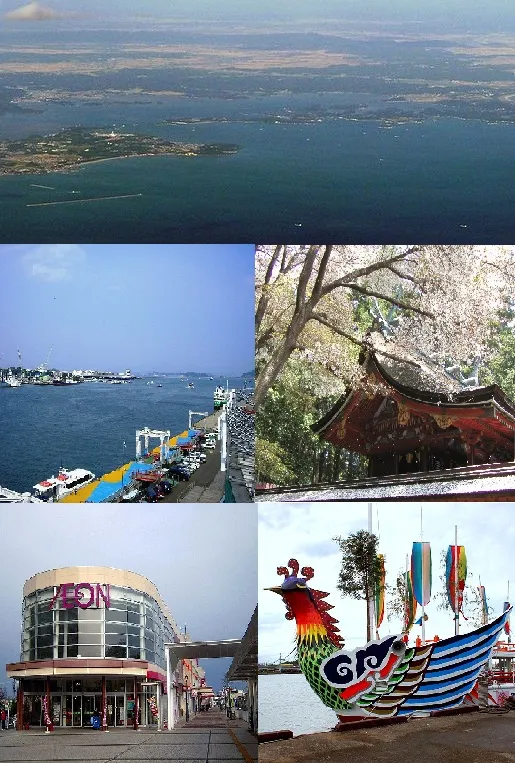
- Population
- 52,662
- 52.7K
- Elevation
- 2 m
- above sea level
- Local time
- UTC+09:00
- Asia/Tokyo · UTC+09:00
- Airports
- SDJ Sendai Airport22 km
- GAJ Yamagata Airport59 km
About Shiogama
Shiogama is a city. Location: Shiogama Shi, Miyagi. Population: 52,662. Elevation: 2 m.
Shiogama (塩竈市 or 塩釜市, Shiogama-shi) is a city located in Miyagi Prefecture, Japan. As of 1 June 2019, the city had an estimated population of 52,662, and a population density of 3,032 persons per km² in 23,270 households. The total area of the city is 17.37 square kilometres (6.71 sq mi).
Source: Wikipedia · CC BY-SA 4.0
Photos of Shiogama
-

Fumihiko Ueno · CC BY 3.0 -

Fumihiko Ueno · CC BY 3.0 -

ketou-daisuki from Kyoto, japansko · CC BY-SA 2.0 -

Fumihiko Ueno · CC BY 3.0


Places bordering Shiogama
- Tagajō-shi
- Rifu
- Shichigahama Machi
Population of Shiogama over time
| 2010 | 56,490 | |
|---|---|---|
| 2015 | 54,187 | |
| 2021 | 51,999 |
Censuses and official estimates; source: Wikidata.
Climate of Shiogama
Best months for sightseeingBest months for sightseeing: May–October.
This month · November
Outside the best season
Day 13° · Night 6° · Rain 66 mm
Better nearby cities in November
- Isehara · 359 km southwest18°
- Kofu · 367 km southwest17°
- Odawara · 379 km southwest19°
- Hottest month
- August (day 27°)
- Coldest month
- January (night -2°)
- Wettest month
- September (180 mm)
- Driest month
- December (34 mm)
Bars: average monthly low and high temperature. Below: precipitation. Monthly averages for 1970–2000 at about 18 km resolution, adjusted for elevation. Highlighted months are mild and relatively dry. Source: WorldClim 2.1 (CC BY 4.0).
Show values as a table
| Month | Jan | Feb | Mar | Apr | May | Jun | Jul | Aug | Sep | Oct | Nov | Dec |
|---|---|---|---|---|---|---|---|---|---|---|---|---|
| Average high (°C) | 5° | 6° | 8° | 14° | 18° | 21° | 24° | 27° | 24° | 19° | 13° | 8° |
| Average low (°C) | -2° | -2° | 1° | 6° | 11° | 15° | 19° | 21° | 18° | 11° | 6° | 1° |
| Precipitation (mm) | 36 | 48 | 68 | 94 | 101 | 129 | 146 | 145 | 180 | 112 | 66 | 34 |
Other places to visit in this season: May June July August September October
How to get to Shiogama
The nearest airport is Sendai Airport (SDJ), 22 km to the southwest as the crow flies. The nearest large city is Sendai, 16 km to the west.
Airports
- Sendai Airport (SDJ) Natori 22 kmsouthwest
- Yamagata Airport (GAJ) Higashine 59 kmwest
- Shonai Airport (SYO) Shonai 122 kmnorthwest
Nearby large cities
- Sendai Population: 1.1M 16 kmwest
- Ishinomaki Population: 140.2K 26 kmnortheast
- Ōsaki Population: 128.8K 31 kmnorth
- Yamagata Population: 248.8K 59 kmwest
- Ichinoseki Population: 114.5K 67 kmnorth
Straight-line distances; road distances are longer. Airport data: OurAirports.
Day trips from Shiogama
Within 100 km: 3 historic and cultural sites, 12 natural sites, 13 lakes, rivers and coasts.
0–25 km6 places
- Miyago Jima Island 11 kmE
- Matsushima Guntō Island 6 kmNE
- Natori Gawa River 17 kmS
- Naruse River River 14 kmNE
25–60 km11 places
- Tashiro Jima Island 34 kmE
- Mount Zaō Mountain 55 kmW
- Mount Zaō Mountain 56 kmW
- Kitakami River River 47 kmNE
60–100 km11 places
- Mount Asahi Mountain 97 kmW
- Takayu-onsen Natural site 89 kmSW
- Asahi Dake Mountain 98 kmW
- Mount Yudono Mountain 95 kmW
Straight-line distances.
Shiogama and similar cities
Side by side with cities of similar size in the same country: population, elevation and climate.
| Measure | Shiogama | Hannan | Noshiro | Shiraoka |
|---|---|---|---|---|
| Population | 52.7K | 52.4K | 52.3K | 52.2K |
| Elevation | 2 m | 78 m | 13 m | 13 m |
| Summer day (hottest month) | 27° | 31° | 28° | 30° |
| Winter night (coldest month) | -2° | 2° | -3° | -2° |
| Annual rainfall | 1,159 mm | 1,445 mm | 1,467 mm | 1,295 mm |
| Best months | May–Oct | May–Jun, Oct | Jun, Sep | May–Jun, Oct |
| Distance | — | 682 km | 227 km | 283 km |
Climate values are 1970–2000 monthly averages; straight-line distance.
Nearby attractions & nature
Everything nearby-
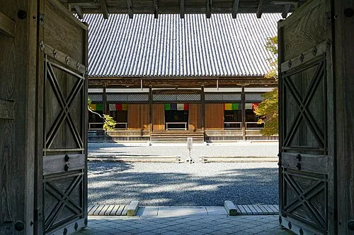 Zuigan Ji Attraction, Matsushima Machi6.6 km N
-
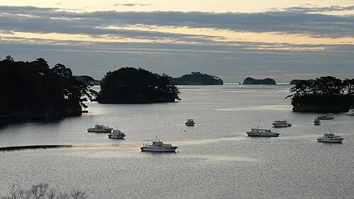 Matsushima Guntō Island, Miyagi5.7 km NE
-
 Miyago Jima Island, Miyagi11 km E
-
Tsuki Shima Island, Miyagi9.7 km NE
-
Naruse River River, Miyagi14 km NE
-
Natori Gawa River, Miyagi17 km S
Sources & licences
Data last updated: · 2 independent sources