- Population
- 11,150
- 11.2K
- Elevation
- 11 m
- above sea level
- Local time
- UTC+00:00
- Europe/London · UTC+00:00
- Airports
- ABZ Aberdeen International Airport27 km
- DND Dundee Airport76 km
About Stonehaven
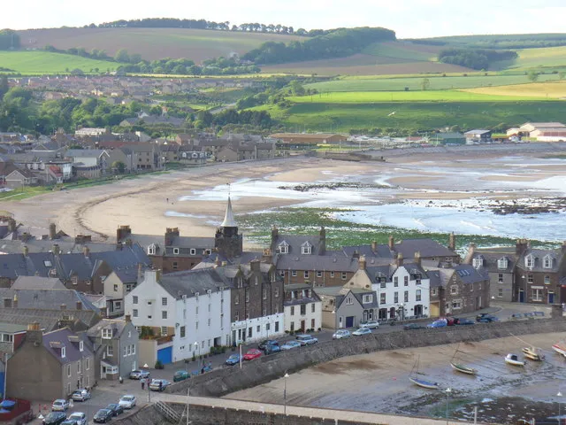
Stonehaven is a town. Location: Aberdeenshire, Scotland. Population: 11,150. Elevation: 11 m.
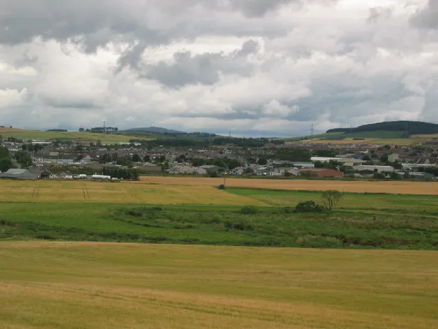
Stonehaven ( stohn-HAY-vən) is a coastal town on the northeast coast of Scotland, 15 miles (24 km) south of Aberdeen. The town had a population of 11,177 at the 2022 Census. Stonehaven is known in the local Doric dialect as Steenhive (Scots pronunciation: [stinˈhɑev] ) and is nicknamed Stoney. It was formerly the county town of Kincardineshire, succeeding the now abandoned town of Kincardine. It is currently administered as part of Aberdeenshire.
Source: Wikipedia · CC BY-SA 4.0
Photos of Stonehaven
-

United Kingdom Hydrographic Office · Public domain -

Smiley.toerist · CC BY-SA 4.0 -

Compo · CC BY-SA 4.0 -

Watty62 · CC BY-SA 4.0 -

Stanley Howe · CC BY-SA 2.0


Travel notes for Stonehaven
From Wikivoyage
Stonehaven is a small fishing port in Aberdeenshire in North East Scotland, 15 miles south of Aberdeen. Its main attraction is Dunnottar Castle, scenically perched on a headland south of town.
Understand+
Stonehaven could be called the most northerly town of the lowlands. Central lowland Scotland is a rift valley, walled by the Highland Boundary Fault which trends diagonally from Helensburgh on the west coast to Stonehaven on the east. Southeast of this line is Old Red Sandstone, bright red from its iron oxides, built into roseate castles such as Edzell, and with red soil in the lowland cattle fields. Northwest are the granite Grampian highlands. As the fault line approaches the coast, it funnels all the transport routes — for cattle-drivers, armies, traders and mail coaches — to the rocky headland where Dunnottar Castle stands guard.
The coastal plain then opens up again further north towards Aberdeen. The "Highland Line" is as much cultural as geological, and this area was an early adopter of lowland agricultural methods, land tenure and industries, and of English in place of Gaelic. Stonehaven's last military upheavals were in the Jacobite campaigns of 1715 and 1745, when it was a supply port for the rebels. Thereafter it was simply a provincial market town, though busy in the 19th century with herring fishing. Its many dank medieval turrets were converted into mansions: these are mostly private residences, but may be occasionally open in summer as part of the Scotland's Gardens Scheme. Stonehaven was the county town of Kincardineshire, but that was abolished in 1975 so it's now part of Aberdeenshire, with a population in 2022 of 11,000.
Stunning Stonehaven is the online visitor information portal.
Get in+
By train:
Hourly trains from Edinburgh and Glasgow Queen Street take two hours via Dundee, Arbroath and Montrose, and continue to Aberdeen. A few are direct from London Kings Cross or Leeds via York and Newcastle, but from England it's usually quicker to change in Edinburgh.
The Caledonian Highland Sleeper to Aberdeen runs Su-F from London Euston, departing after 9PM to reach Stonehaven around 7:15AM. The southbound train picks up around 10PM to reach Euston towards 8AM. You could also take the Lowland Sleeper from Euston towards midnight and change to a day train in Edinburgh. Going back, you need to leave Stonehaven before 8:30PM to join the southbound Lowland Sleeper at 11:30PM from Edinburgh.
1 Stonehaven station is a mile west of town centre. There's a ticket office, machines, toilets and a waiting area, with step-free access to both platforms. Exit onto Arduthie Rd, where the Station Hotel has a bar and serves meals; head downhill east for more food and pubs in the centre.
By bus:
Stagecoach North Bus 8 runs hourly daytime from Aberdeen Union Square, taking an hour via Portlethen, Newtonhill and Chapeltown. At night take Bus X7.
2 Barclay Street is the main bus stop, at the corner with Cameron Street a block south of Market Square.
Coaches from Edinburgh, Glasgow and the south towards Aberdeen scoot past on the A90 and don't stop in Stonehaven.
By road:
From north or south the quickest road is A90, which cuts inland. For a slower scenic route (eg cycling) take A92, which follows the coast from Dundee via Arbroath and Montrose.
To reach the Cairngorms, A957 northeast (the lyrically-named "Slug Road") joins A93 at Crathes: this is the route between Glenshee, Braemar, Balmoral and Aberdeen.
Source: Wikivoyage · CC BY-SA 4.0 · abridged
Climate of Stonehaven
Best months for sightseeingBest months for sightseeing: June–August.
This month · November
A cold month
Day 8° · Night 1° · Rain 81 mm
- Hottest month
- July (day 19°)
- Coldest month
- January (night -1°)
- Wettest month
- January (88 mm)
- Driest month
- April (49 mm)
Bars: average monthly low and high temperature. Below: precipitation. Monthly averages for 1970–2000 at about 18 km resolution, adjusted for elevation. Highlighted months are mild and relatively dry. Source: WorldClim 2.1 (CC BY 4.0).
Show values as a table
| Month | Jan | Feb | Mar | Apr | May | Jun | Jul | Aug | Sep | Oct | Nov | Dec |
|---|---|---|---|---|---|---|---|---|---|---|---|---|
| Average high (°C) | 5° | 6° | 9° | 12° | 15° | 18° | 19° | 19° | 16° | 12° | 8° | 5° |
| Average low (°C) | -1° | -1° | 1° | 3° | 5° | 8° | 10° | 10° | 8° | 5° | 1° | -1° |
| Precipitation (mm) | 88 | 59 | 62 | 49 | 56 | 55 | 60 | 68 | 73 | 86 | 81 | 77 |
How to get to Stonehaven
The nearest airport is Aberdeen International Airport (ABZ), 27 km to the north as the crow flies. The nearest large city is Aberdeen, 21 km to the north.
Airports
- Aberdeen International Airport (ABZ) Aberdeen 27 kmnorth
- Dundee Airport (DND) Dundee 76 kmsouthwest
- Inverness Airport (INV) Inverness, Highland 128 kmnorthwest
Nearby large cities
- Aberdeen Population: 198.6K 21 kmnorth
- Dundee Population: 148.2K 72 kmsouthwest
- Edinburgh Population: 515K 128 kmsouthwest
- Glasgow Population: 626.4K 176 kmsouthwest
- Newcastle upon Tyne Population: 300.1K 225 kmsouth
Straight-line distances; road distances are longer. Airport data: OurAirports.
Day trips from Stonehaven
Within 100 km: 73 historic and cultural sites, 1,611 natural sites, 271 lakes, rivers and coasts.
0–25 km147 places
- Aberdeen Beach Beach 23 kmN
- Loch of Skene Lake 22 kmN
- Black Loch Lake 24 kmW
- Cairn o’ Mount Mountain 24 kmW
25–60 km544 places
- Balbithan Island Island 32 kmN
- Newburgh Seals Beach Beach 41 kmN
- The Donnons Island 55 kmNE
- Inch Geck Island 44 kmN
60–100 km1,264 places
- Findlays Seat Mountain 90 kmNW
- Sunnyside Beach Beach 88 kmNW
- Mugdrum Island Island 93 kmSW
- Isle of May Island 89 kmS
Straight-line distances.
Nearby attractions & nature
Everything nearby-
Cowie Water River, Aberdeenshire0.5 km NE
-
Cowie Harbour Natural site, Aberdeenshire0.7 km SE
-
Stonehaven Bay Natural site, Aberdeenshire0.8 km NE
-
Carron Water River, Aberdeenshire1.5 km S
-
Strathlethan Bay Natural site, Aberdeenshire1.7 km SE
-
Old Hall Bay Natural site, Aberdeenshire1.7 km SE
-
Castle Haven Natural site, Aberdeenshire1.7 km SE
-
Dunnottar Castle Historic site, Aberdeenshire2.2 km SE
Other cities and towns in Aberdeenshire
Sources & licences
Data last updated: · 2 independent sources